Tuesday, August 24, 2021

Day 44 (7/9): Miles traveled: ~ 210

Location: half the day at Cascade Lake, then to Twin Falls, ID

Science: air quality measurements (both particulate counter and MicroTops measurements) for half the day at lake peninsula camping spot on Lake Cascade (near dam outlet on Payette River) -- wildfire haze increasing -- then measurements in hotel parking lot in Twin Falls, ID

We spent most of the day hanging out at Lake Cascade, watching the wildfire smoke haze build and further obscure mountain views. 

Rosie tried some new fishing strategies, but still no bites on her line. She had decided to give up just as we sat down to lunch.  As we ate, we realized that we had a new friend -- a cute chipmunk was hanging out under the table waiting for us to get sloppy -- 


Right after we took this picture, a hawk flew over our campsite, gripping a struggling silver fish in its talons. "I guess there ARE fish in that lake!" Rosie cried, and grabbed her pole and went back out to fish. 


She got two true bites before we had to leave for Twin Falls, ID. I had decided we had to stay in a hotel because I could not find open campsites between Lake Cascade and Yellowstone. 

On the drive, Rosie and I figured out that if she used her headphones from her tablet, I could still listen to my books-on-audible, so I finished up Braiding Sweetgrass and jumped into West of the Revolution. This was a very interesting accompanying text for this stage of our journey -- and, as usual, full of history that I had either never known, was lied to about, or just had the privilege to think I did not need for my scientific work. Wow, was I mistaken.

We stayed at the Motel 6 once we made it to Twin Falls. It was not fancy, but we got pizza delivered and watched Luca. Again. Still loved it.


Day 43 (7/8): Miles traveled: ~ 340

Location: various roadside sites, a random idyllic river beach (near White Bird, ID), ending at lakeside campground (Lake Cascade)

Science: air quality measurements (both particulate counter and MicroTops measurements) in Lewiston, ID (top and bottom of hazy river valley); Salmon River beach (White Bird, ID), and lake peninsula camping spot on Lake Cascade (near dam outlet on Payette River) -- obvious wildfire haze building across the Lake, we had a tiny campfire for smores only that night

Before we left Farragut State Park this morning (early, so we could find some ice!), we searched for the big lake near our campground. Here is what we found (if I hadn't been there myself I would have sworn we were in Austria or Swiss Alps or something):


Rosie was bummed that we hadn't found this the night before because she really, really, really wanted to go fishing. I assured her that we would likely be able to fish all day at the next site (Lake Cascade). 

We then headed south (we were slowly making our way toward Yellowstone, one of the few National Parks I had not yet seen/experienced on past roadtripping adventures).  Today's drive is when I finally realized just how LONG Idaho is. I am originally from Illinois, and on that side of the Mississippi everyone thinks Illinois is incredibly long (folks are constantly amazed that I grew up in Illinois, but was closer to the South (Kentucky, Tennessee) than I was to Chicago). Idaho is much longer, and 1.5 times the area of Illinois, but has less than 1/10th of the population of Illinois. 

Fun facts aside, this was a very interesting driving day. Mountains and rivers create a rough and rawly gorgeous landscape, and it was really HOT and DRY. The elevation changes allowed for very good haze-tracking -- there was clearly a big fire nearby and the smoke did not seem to be very high in the atmosphere.  

Our first stop was at the top of a canyon formed by the Clearwater River, with a view of Lewiston, ID --


Once we got down into the valley, we stopped again to make air quality measurements in a parking lot by Lewiston's river access -- the area seemed very industrialized, with a very fragrant paper mill and other river-based activities along the waterfront.


After Lewiston, it kept getting hotter and hotter outside. And when we hit the Salmon River near White Bird, ID, there were folks swimming in the blue-green river at all sorts of random spots along the highway. Finally, Rosie and I soon succumbed to the swimming urge and stopped at a great spot for lunch. 


We swam for a long time and even saw a tiny river otter swim by us!

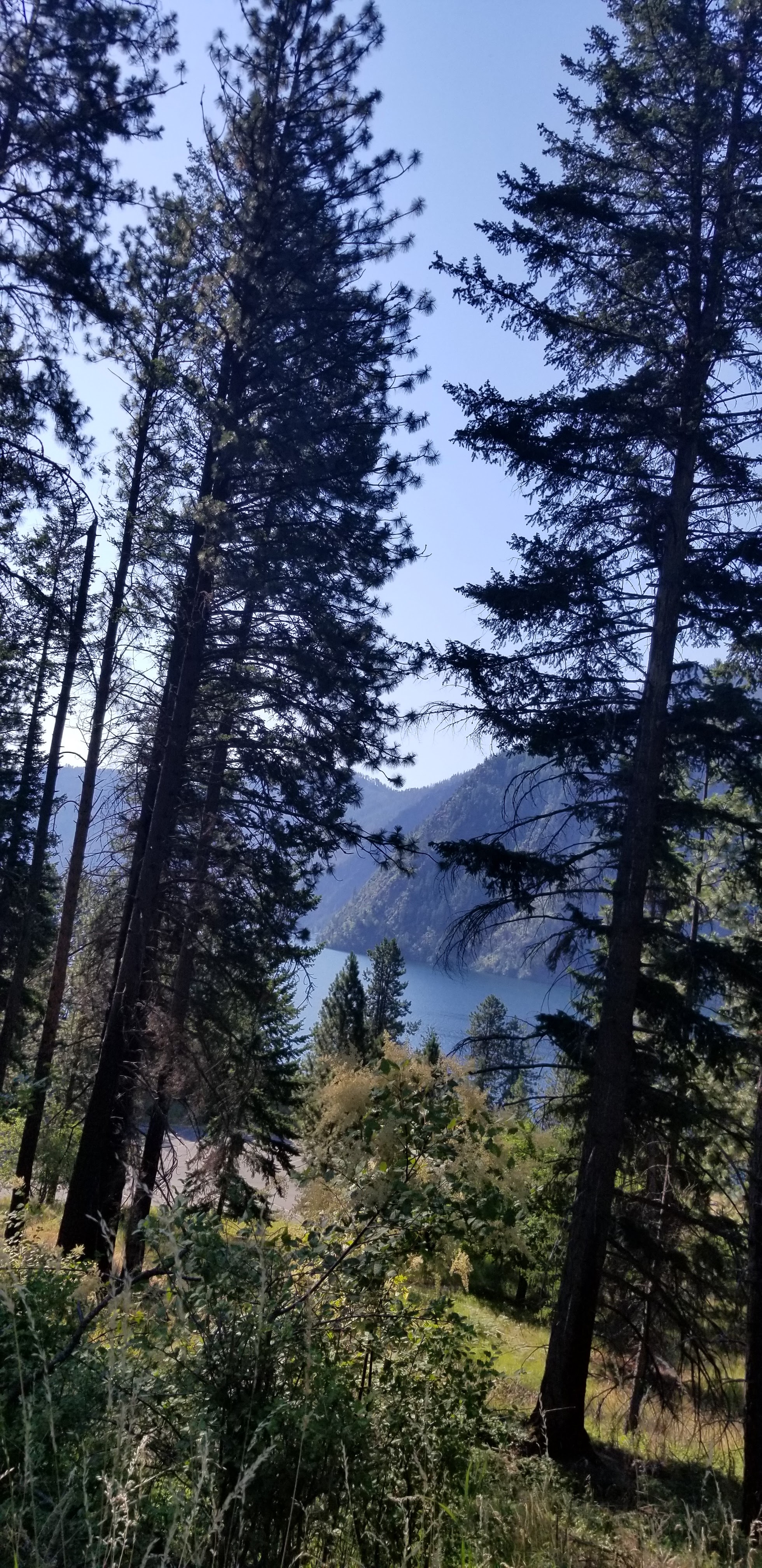
Next stop was Lake Cascade. As we drove into the site, the haze seemed to be thickening across the lake.


Rosie was ecstatic about the location of our site -- surrounded by great fishing access. She fished the entire rest of the day (when she wasn't swimming). 


The sunset was outrageously red, more evidence of wildfire smoke in the atmosphere -- 


Rosie and I had a tiny campfire for smores -- weak moment #2 on the trip, facilitated by the need for cheering up Rosie, who, despite her best and patient efforts, did not get a single fish bite on her line. She began to question whether or not there were actually fish in the huge human-made lake, and went to bed plotting other tactics to use the next day.


Day 42 (7/7): Miles traveled: ~ 305

Location: various Eastern Washington sites, ending in Athol, ID

Science: air quality measurements (both particulate counter and MicroTops measurements) at Ellensburg, WA bus station (haze evident, lots of car traffic); Snowberry Campground (Farragut State Park)

Sadly, we dropped Beate off at the Ellensburg, WA (very much a cowboy town) bus station today so she could head back home. Rosie was not happy about losing her aerodynamics pal, even though she got to meet the town mascot --


Beate gifted us with the loan of the fancy Microtops sensor for the rest of the trip. I got trained on using it -- MUCH more difficult than I thought to get the sun lined up correctly with the sensor. 


When we headed out of Ellensburg on the way to Northern ID, haze began appearing on the horizon again:


We stopped in Athol, ID (near the campground -- I can't help it but the name of this town reminds me of that stupid kid joke where you tell your little brother to hold his tongue while saying "apple".....terrible and childish as heck, I know) to get groceries and were informed that there was no ice in a 60-mile radius......apparently Covid19 had decimated the workforce at the ice distributor and there was no one to cut the ice or deliver......Rosie and I had a little ice left in the cooler so we crossed our fingers and did not open the cooler much once we packed it with new food. 

The Farragut State Park campground was fine -- no views of water (honestly I had no idea we were even near water), but the campground was full and campfires were going for most of our stay.


Rosie did her organizing magic in the trailer cabin -- 


and then we played a ton of ladder ball -- I actually won one round -- 


Day 41 (7/6): Miles traveled: ~ 140

Location: various Columbia Gorge sites, ending at Cedar Springs Campground, Naches, WA (on the Bumping River)

Science: air quality measurements (both particulate counter and MicroTops measurements) at Maryhill Museum, Cedar Springs Campground (there were more campfires here, we used the gas firepit here as well to roast marshmallows for dessert)

After our beach day, we decided it was time to head inland along the Columbia Gorge -- things quickly changed from lush green to intensely golden hills and very dry climate. The skies were actually clear, haze not as evident (that is Mt. Adams in the background....I think? Or maybe Rainier?). Please ignore the bald face and hat ring on my bald head.


We stopped at one of the quirkiest museums I have ever been to -- the Maryhill Museum of Art. Built by Sam Hill (as in "What in the Sam Hill do you think you are doing?") on the banks of the Columbia River. 


The museum had a surprisingly extensive exhibit of Indigenous arts and culture. I could not tell if this was a good thing -- still need to research the history around this museum -- but my gut says no, no, it is not a good thing that this museum run by white people has all of the gorgeous Indigenous works of life and art I saw there. This is on my list to take a deep dive on when Fall semester begins.

Perhaps more fittingly, they had a huge collection of chess sets -- Rosie loves chess, so this was fun for her to explore.


There also was an entire wing dedicated to turn of the century white folks fashion. As far as I could tell, there were around 50 12-inch dolls dressed in exact replicas of high fashion......


I set the air quality sensor up in the far end of the Maryhill Museum parking lot, and we took some Microtops measurements there as well. 


We passed some windfarms on our way to our next camping site -- 


Cedar Springs Campground was beautiful. I was relieved to be back in the green after a day of dry golden landscapes.


The campsite was right on the Bumping River, which was cool but not freezing. Rosie tried out her remote control boat as Beate explored swimming options.  


Day 46 (7/11): Miles traveled: ~ 250 Location: Yellowstone, ending at Best Western in Billings, MT Science: air quality measurements (both p...